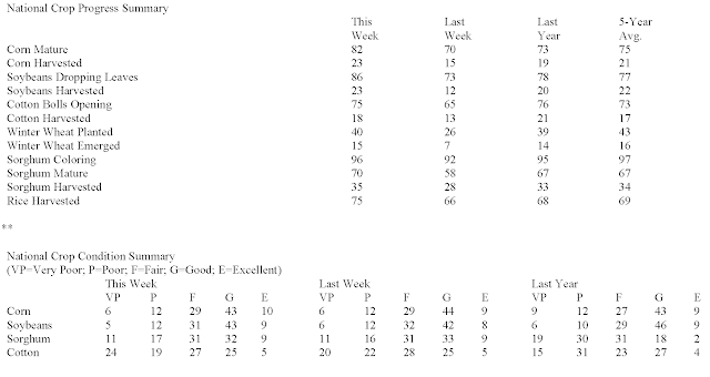
OMAHA (DTN) -- Widespread rain in Minnesota and Wisconsin led to some harvest delays in those states last week, but mostly dry, warm weather over much of the central Corn Belt kept the overall row-crop harvest rolling along, according to USDA NASS' weekly Crop Progress report on Monday.
CORN
-- Crop progress: NASS estimated that 82% of corn was mature as of Sunday, Oct. 1, 9 percentage points ahead of last year's 73% and 7 points ahead of the five-year average of 75%.
-- Harvest progress: Corn harvest moved ahead 8 percentage points last week to reach 23% complete as of Sunday. That is 4 percentage points ahead of 19% last year and 2 percentage points ahead of 21% for the five-year average. "Illinois' corn is 23% harvested, and Iowa is at 16% harvested," noted DTN Senior Analyst Dana Mantini.
-- Crop condition: NASS said 53% of the corn crop was rated good to excellent, unchanged from last week and slightly above 52% a year ago.
SOYBEANS
-- Crop progress: 86% of the crop was dropping leaves, 8 percentage points ahead of last year's 78% and 9 points ahead of the five-year average of 77%.
-- Harvest progress: NASS estimated that 23% of the crop had been harvested as of Sunday, up 11 points from the previous week. This year's progress is 3 points ahead of last year's 20% and 1 point ahead of the five-year average of 22%. "Illinois' soybeans are 19% harvested, and Iowa is at 24% harvested," Mantini said.
-- Crop condition: USDA said 52% of the soybean crop was rated good to excellent, back up 2 points from 50% the previous week but still below 55% a year ago.
WINTER WHEAT
-- Planting progress: Winter wheat planting advanced 14 percentage points last week to reach 40% complete as of Sunday. That is 1 point ahead of last year's 39% but 3 points behind the five-year average of 43%. "Kansas was 37% planted, at its usual pace, and Washington was at 65% planted, a little behind the five-year pace," noted DTN Lead Analyst Todd Hultman. "Planting is noticeably slower than normal in Idaho, Indiana, Michigan, Ohio, Oregon and Oklahoma."
-- Crop progress: 15% of the crop had emerged as of Sunday, 1 point ahead of last year's 14% but 1 point behind the five-year average of 16%.
WEATHER OUTLOOK FOR THE WEEK AHEAD
A strong cold front will move east across the country later this week, which is likely to bring the first widespread frost to the Northern Plains and Upper Midwest. That is typical for early October or even a little later than normal, according to DTN Ag Meteorologist John Baranick.
"It's going to be a volatile week east of the Rockies," Baranick said. "Heat that built in over the weekend made it feel like midsummer with highs in the 80s and 90s Fahrenheit. That continues until a very strong cold front moves through. A trough out in the West will move east and push the front. Temperatures will drop a good 10-15 degrees immediately behind the front, but colder air filtering in behind it will drop high temperatures below normal for most areas late week and weekend.
"The first widespread frost event is likely for the Northern Plains and Upper Midwest, which is typical for early October or even a little later than normal. If frosts can make it down into Kansas and Nebraska or the Ohio Valley, it would be a week or two early. Either way, frost is unlikely to have much of an influence on this year's crop since it is so advanced. It probably won't matter for winter wheat either that is just starting to get established.
"Scattered showers and thunderstorms will come with the front and should be fairly widespread. The front will be progressing, so most areas should see light to moderate rain. A few thunderstorms could produce some heavier bursts, but that should be isolated. The front will be slower to get through the Southern Plains, though, so they could see some heavier rain to battle the ongoing drought. Overall, though, harvest and winter wheat planting progress should not be affected for too long. Any rain that comes to the southwestern Plains will help with establishment there.
"The cold won't last too long, though, as temperatures are forecast to rise again next week," Baranick said.


No comments:
Post a Comment