The storm track remained active across much of the contiguous U.S. (CONUS) this week. Much of the Northern Tier states experienced beneficial rainfall and near to below-normal temperatures, predominantly leading to drought improvements from the Pacific Northwest to the Northern Plains. Storm systems and clusters of thunderstorms also resulted in some improvements from the Mississippi Valley to the East Coast. However, where the heaviest rains did not fall, there was some deterioration and slight expansion of abnormal dryness or drought conditions, particularly in parts of the Southeast and Ohio and Tennessee Valleys. Above-normal temperatures and below-normal precipitation was the main story across much of the southwestern CONUS, extending into Texas, leading to general persistence and degradation of drought conditions. Weak trade winds in Hawaii and below-normal precipitation in Alaska have continued, resulting in degradations this week. Warm and dry conditions also contributed to worsening conditions in Puerto Rico.
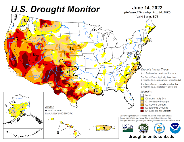
Seasonal temperatures were observed across much of the Northeast this week. Above-normal precipitation fell across much of the region also, with the exception of a few pockets across northern New England and the coastal Mid-Atlantic. Some minor degradations were warranted in parts of Maine, where precipitation was below-normal this week and USGS 7 to 28-day average stream flows have fallen below-normal. Soil moisture anomalies also remain negative across much of the state, according to CPC Leaky Bucket soil moisture (0.75 to 1.5 inch negative anomalies). In southern New England, moderate drought (D1) was slightly reduced in coverage across eastern Massachusetts, where more than 2 inches of rain fell. However, this was not enough to eliminate 60 to 90-day precipitation deficits (2 to 6 inch 90-day deficits), so no additional improvements were warranted, despite much above-average precipitation at some locations. Additionally, by the end of the valid 7-day period (6/14), USGS daily stream flows had already begun to fall below-normal again, despite improved 7-day average stream flows from the heavy rainfall.
Mixed improvements and degradations are warranted across the Southeast. 1-category improvements in the southern Florida Peninsula are based on positive 7-day precipitation accumulations of more than 3.5 inches, improved stream flows, and soil moisture (aided by the passage of the remnants of Hurricane Agatha from the East Pacific earlier this month). In the Coast Plain of the Carolinas, locations that experienced 1 inch or greater surpluses of precipitation this week also saw improvements. However, improvements were very targeted in nature due to long-term (180-day) rainfall deficits remaining mostly intact, despite the above-normal precipitation. The Piedmont and upstate areas of the Carolinas and much of eastern and southern Georgia, where rainfall was generally below-normal this week, saw expansion of abnormal dryness (D0) and moderate drought (D1) conditions. A report from South Carolina indicates leaf rolling, stunted growth, and shallow roots on corn crops caused by stress from insufficient soil moisture, which is further supported by NASA SPoRT soil moisture estimates (widespread root-zone soil moisture below the 10th percentile of the historical distribution). These areas continue to be susceptible to rapid degradation in the coming weeks, given the potential for excessive heat and below-normal precipitation favored over the next couple of weeks, and will be an area to watch. D0 areas in parts of northern Alabama were removed, associated with much above-normal rainfall from Birmingham northward toward the Tennessee Valley and seasonal average temperatures for the week.
Short-term (30 to 60-day) rainfall deficits continue to mount across parts of the Lower Mississippi and Tennessee Valleys. Coverage of D0 (abnormal dryness) was generally expanded, although coverage is sporadic. Seasonal temperatures in these areas helped keep evapotranspiration rates at bay this week. However, daily soil moisture anomalies continue to become more negative, particularly over the past couple of weeks from northern Louisiana, extending northeastward toward the Tennessee Valley, as several locations have seen continued declines in surface moisture. Similar to the Carolinas, these areas will need to be watched in the coming weeks, as potentially excessive heat and below-normal precipitation is forecast through the end of the month. Drought deterioration is also warranted across much of Texas, which saw another week of much above-normal temperatures, high winds, and below-normal precipitation. Some of these degradations extended into western Louisiana also. However, in eastern Louisiana, a cluster of thunderstorms provided some relief to abnormally dry (D0) and moderate drought (D1) areas. Improvements are also warranted in western Oklahoma, particularly in areas that received at least 1 inch rainfall surpluses this week. Some 2-category improvements occurred in areas where year-to-date precipitation deficits declined and daily soil moisture estimates improved to near-normal down to 200 cm.
The Upper Midwest remained cooler than normal and generally wetter than normal, leading to some improvements in abnormally dry (D0) areas. Conversely, parts of the Corn Belt and Ohio Valley have started to dry out, as precipitation has been hit-or-miss in recent months, pushing short-term deficits to increase further (60-day rainfall deficits of more than 3 inches in many locations). As such, targeted expansion of D0 was warranted in parts of Kentucky, Indiana, Illinois, and Missouri. In addition, root zone soil moisture has fallen below the 20th percentile of the historical distribution (NASA SPoRT) along with nearby 7-day average stream flows, which have fallen below-normal (ranked between 10th to 24th percentiles by the end of the valid period - 6/14).
Much of the High Plains Region has seen beneficial rainfall and temperatures averaging near to below-normal over the past 30 days. However, above-normal temperatures finally crept in this week, as temperatures ran more than 3°F above-normal for much of the region. Despite the above-normal temperatures, precipitation was also above-average for many locations, warranting broad 1-category improvements in the drought depiction where more than 1 inch 7-day surpluses were observed and where longer-term deficits were appreciably diminished. Only areas in southwestern Colorado and just east of the Front Range in Wyoming experienced some degradation, as temperature anomalies were highest in those areas (6°F to 9°F above-normal). Also, high winds have helped to exacerbate ongoing drought in those locations.

Much of the Northern Tier of the U.S. from the Pacific Northwest to the Northern Plains, has seen marked improvements in recents months due to a persistent storm track and near to below-normal temperatures. That same pattern continued this week and continued to eat away at long-term precipitation deficits and indicators, such as groundwater. Additionally, some high-elevation locations have even picked up additional snowpack and stream flows are running near to much above-normal over the past 28 days. Given the wet conditions in recent months and the continuation of the active storm track, broad improvements are warranted again this week. The only exception is parts of north-central Montana, where precipitation has generally missed many areas near the Golden Triangle in recent months, warranting some slight degradation this week, as precipitation again missed these areas. Elsewhere in the Western Region, despite the much above-normal temperatures, a general status quo depiction was warranted, the exception being Nevada and New Mexico. A slight expansion of extreme drought (D3) was warranted in central Nevada, where 7 to 28-day average stream flows are running below the 5th percentile of the historical distribution, vegetation indices are indicating similar signals as D3 areas to the east, and KBDIs are indicating high soil moisture deficiency in the upper layers. Despite some nearby monsoon precipitation in parts of New Mexico and Arizona, accumulations were not enough to change the severe (D2) to exceptional (D4) drought depictions in areas where the rains fell. Given the temperatures were running anywhere from 5°F to 10°F above-average, and coupled with windy conditions, additional degradations were made in parts of western and southern New Mexico. Additionally, CPC soil moisture continues to remain below the 5th percentile much of the region and nearby stream flows are averaging in the bottom 2 percent of the historical distribution.

In Puerto Rico, rainfall in excess of 2 inches fell across parts of western interior parts of the island. However, amounts were not enough to eliminate short-term (90-day) deficits. Farther east, below-normal precipitation was observed this week and stream flows have fallen below the 10th percentile of the historical distribution. As such, D0 (abnormal dryness) and D1 (moderate drought) were expanded in coverage across the southeast. In the northeast, the addition of D2 (severe drought) was warranted, where stream flows have fallen below the 10th percentile and 90-day rainfall deficits have reached upwards of 12 to 16 inches (per Advanced Hydrologic Prediction Service estimates).
Hot, mostly dry weather prevailed across the U.S. Virgin Islands, along with periods of haze and reduced air quality due to Saharan dust. The islands’ drought status was unchanged, with extreme drought (D3-SL) noted on St. Croix and severe drought (D2-SL) reported on St. Thomas and St. John.
The short-term component of the drought remains a grave concern to agricultural interests, as hot, dry conditions have boosted water demands and have stressed pastures, crops, and native vegetation. During the first 2 weeks of June, rainfall totaled less than one-quarter inch at all available observation sites on St. Thomas and St. John. Only spotty June 1-14 totals above one-half inch were observed on St. Croix. Official June 1-13 totals included 0.04 inch (4% of normal) at King Airport on St. Thomas and 0.12 inch (15% of normal) at Rohlsen Airport on St. Croix. Rohlsen Airport capped the drought-monitoring period with consecutive daily-record highs of 92°F on June 12-13. King Airport reported a high temperature of 90°F or greater for the first time this year on June 12.
Meanwhile, the long-term component of the drought has contributed to diminishing groundwater reserves. Data from U.S. Geological Survey wells – one on each major island – continued to exhibit increases in depth to water. On St. Croix, for example, the depth to water at the Adventure 28 Well increased to 33.77 feet on June 14, compared to less than 10 feet in late 2017. Similarly, depth to water at the Susannaberg DPW 3 Well on St. John has increased more than 20 feet since late 2017.
Much of southern Mainland Alaska was experiencing abnormally dry (D0) conditions, with a small region of south-central Alaska depicted in moderate drought (D1), leading up to this week due to above-normal spring time temperatures and below-normal precipitation. With the exception of interior Mainland Alaska, above-normal temperatures were observed this week over many of these same areas, as well as below-normal precipitation. Soils have continued to dry out, despite some late season snow melt in some locations, warranting further deterioration of conditions. This resulted in the expansion of D0, the addition of new D1 areas in the southeastern and central Mainland, and the addition of severe drought (D2) along the Susitna River. In addition, lightning season started early this month, so ongoing dryness and gusty winds continue to enhance the wildfire risk, especially as the largest documented tundra fire burns in southwestern Alaska.
In Hawaii, drought deterioration was warranted this week. A dry time of year coupled with weak trade winds and below-normal precipitation led to some targeted 1-category degradations along the island chain. Stressed and browning vegetation was reported on eastern Oahu and stream flows have continued to decline since the start of the month in most locations throughout the islands.
In recent days, the Intertropical Convergence Zone (ITCZ) arched north of Kwajalein and Majuro, delivering locally heavy showers to the northern Marshall Islands. Following the previous week’s 4-inch rainfall total on Wotje, additional showers led to a change in categorization of abnormally dry conditions from D0-SL to D0-L, to reflect any lingering impacts from the recently ended drought. Neither dryness nor drought existed elsewhere in the Marshall Islands. Kwajalein reported measurable rain on each of the first 14 days of June, totaling 5.61 inches. Majuro noted 1.57 inches of rain on June 10. Data for Utirik remains unavailable.
Meanwhile, the Mariana Islands continued to await more regular rainfall in conjunction with the onset of the rainy season, allowing D0-S to persist for Saipan, Rota, and Guam. Only scattered observation sites in the Marianas received more than an inch of rain during the drought-monitoring period. On Guam, the Keeth-Byram Drought Index (KBDI) climbed as high as 685 before retreating slightly, indicating a high fire danger.
Farther south, ample rain continued to fall across the Federated States of Micronesia (FSM), except on Kapingamarangi. No measurable rain has been reported on Kapingamarangi during five of the last 6 weeks, resulting in severe drought (D2-SL). According to reports from Kapingamarangi, vegetation is turning yellow and water levels for both private and public water tanks are at roughly 30% of capacity – and a ship recently delivered water supplies to the island. Elsewhere in the FSM, Lukunor has received less than an inch or rain during three of the last five drought-monitoring periods and will continue to be monitored for the need to introduce abnormal dryness. Data for Fananu remains unavailable.
Elsewhere, generally abundant rain continues to fall across the Republic of Palau and American Samoa. Month-to-date rainfall in the Republic of Palau has totaled 5 inches or more at several locations, including Airai and Koror. In American Samoa, the international airport has been a bit dry so far this month, with 0.92 inch reported through June 14. However, much higher amounts (around 2 inches during the drought-monitoring period) have been reported at the National Park Service weather stations on Siufaga Ridge and Toa Ridge.
Looking Ahead
A storm system with a trailing frontal boundary will exit the northeastern contiguous U.S. (CONUS) over the next 2 days (June 16-17), bringing below-normal temperatures and chances for precipitation to parts of the Great Lakes and Northeast. High pressure is forecast to build over the central CONUS and spread eastward through Tuesday, June 21. Maximum temperatures across parts of the north-central CONUS may reach 15°F to 20°F above-normal. The northwestern CONUS is expected to remain active, as another storm system is forecast to push onshore into the Pacific Northwest and into the Intermountain West during the weekend and leading up to the Tuesday cutoff. With it will come increased chances for precipitation in areas that experienced improvements in recent weeks. Below-normal temperatures are also forecast across much of the western third of the CONUS, in the wake of this passing system.
The Climate Prediction Center’s 6-10 day outlook (valid June 21-25, 2022) favors above-normal temperatures and near to below-normal precipitation across the eastern CONUS. Below-normal temperatures and below-normal precipitation are favored across the Pacific Northwest and northern Great Basin, in the wake of a passing storm system near the start of the 6-10 day period. However, there is a weak tilt in the odds toward above-normal precipitation in northern Washington. A surge of moisture is expected to bring increased chances of precipitation to the Four Corners region, signaling a potential early start to the Southwest Monsoon season, with probabilities of above-normal precipitation extending northeastward into portions of the Central and Northern Plains. Near to below-normal precipitation and above-normal temperatures are favored over much of California.


.png)